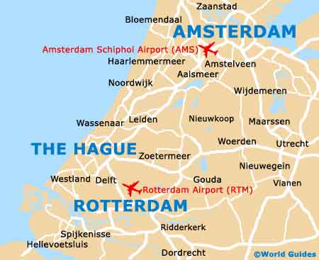
The Hague Maps and Orientation
(The Hague / Den Haag, South Holland, Netherlands)
The Hague is referred to on many Dutch maps as 'Den Haag' and is a sprawling city and located on the western side of the
Netherlands, in the region on South Holland (Zuid Holland). Close to the heart of the city, The Hague's Centraal Station (CS) is an important transport hub and this busy railway station is easy to find.
The other train station in The Hague is the Hollands Spoor Station (HS) and this is located further south, being just over 1 km / 0.5 miles from the city centre itself. Most of the streets that head in a westerly direction reach the Scheveningen resort area and its sandy beachfront, which is graced by a long pier, a lighthouse and also a scenic esplanade.
Maps and Orientation of the City
In total, The Hague is home to eight main districts, including Scheveningen, with many people basing themselves around the city centre, although it is true to say that The Hague has no true core itself. The central part of the city comprises a total of nine different neighbourhoods, such as Archipelbuurt, Stationsbuurt, Oude Centrum and also Kortenbos, previously an industrial area and recently redeveloped.
Maps of The Hague can be obtained at the Van Stockum bookstore on the Venestraat, and many travel books are also available. The outlying outskirts of the city are especially pretty and lined with trees, while close by are many interesting destinations, such as Delft, which can be reached in less than 30 minutes by tram (no. 11), or under ten minutes by train.
- Almere - 85 km / 53 miles (one hour and 25 minutes, north-east)
- Amersfoort - 87 km / 54 miles (one hour and 25 minutes, east)
- Amsterdam - 59 km / 37 miles (one hour and five minutes, north-east)
- Dordrecht - 52 km / 32 miles (55 minutes, south-east)
- Eindhoven - 144 km / 89 miles (one hour and 50 minutes, south-east)
- Gouda - 32 km / 20 miles (35 minutes, east)
- Hilversum - 82 km / 51 miles (one hour and 20 minutes, north-east)
- Lansingerland - 23 km / 14 miles (30 minutes, east)
- Leiden - 21 km / 13 miles (25 minutes, north-east)
- Rotterdam - 25 km / 16 miles (30 minutes, south-east)
- Vlaardingen - 31 km / 19 miles (35 minutes, south)
- Wassenaar - 12 km / 7 miles (20 minutes, north)
- Westland - 14 km / 9 miles (20 minutes, south)
- Woerden - 48 km / 30 miles (50 minutes, east)
- Zoetermeer - 15 km / 9 miles (20 minutes, east)
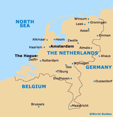
Map of The Netherlands
Map of The Hague